Guam Antonio B. Won Pat International Airport (GUM)
Orientation and Maps
(Guam, Guam)
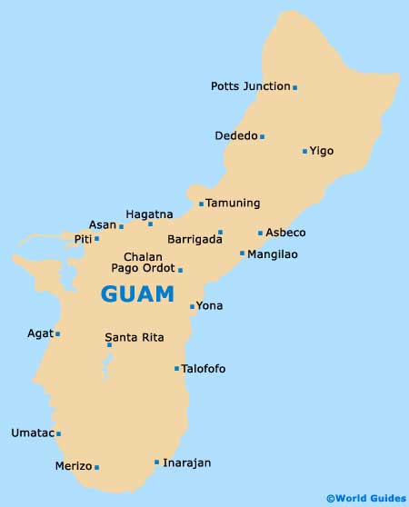
With a total population of approximately 170,000 inhabitants, the island of Guam is located in the Western Pacific Ocean. A beautiful island with a rich history dating back many thousands of years, Guam is officially known as the US Territory of Guam. Part of the Mariana Islands archipelago, Guam is home to a thriving tourist industry and regularly attracts visitors from both Japan and China.
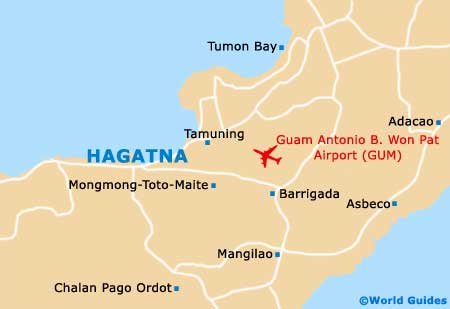
Located on the north-eastern side of Hagatna, the island's capital, the Antonio B. Won Pat International Airport (GUM) is close to the very heart of the island. An important hub used by Continental Micronesia airlines, the airport offers easy access to the whole of Guam.
Guam Antonio B. Won Pat International Airport (GUM) Maps: Important City Districts
Hagatna (also known as Agana) is a notable town and has a population of around 1,200 residents. Located on the northern side of the island's centre, Hagatna regularly hosts many seasonal festivities, including Liberation Day each July, where a major parade is held along Marine Drive. Other highlights around Hagatna include the Plaza de Espana and also the historic basilica.
Located on the eastern shore of Guam and close to Hagatna, the village of Mangilao is best known for its prominent educational institutes, which include the University of Guam. Other noteworthy areas of Guam are as follows:
- Aga Point (south)
- Agat (west)
- Apra Heights (west)
- Cocos Lagoon (south)
- Dededo (north)
- Inarajan (south-east)
- Lockwood Terrace (west)
- Merizo (south)
- Oceanview (north-west)
- Pagat Point (north-east)
- Pati Point (north-east)
- Ritidian Point (north)
- Santa Rita (west)
- Talofofo (east)
- Tumon Bay (west)
- Umatac (south-west)
Guam Map
Hagatna Map